
Regional Breakdown
The month of June was both good and bad for the High Plains. Record precipitation greatly improved drought conditions for some, while others continued to remain dry. Drought conditions continued to intensify in the eastern portions of the region, leading to significant impacts.
The dryness plaguing the central and eastern parts of the region has created lasting impacts. The lack of recharge this past winter has led to several cities implementing water restrictions in an effort to conserve the precious resource. The town of Waverly was forced to designate emergency restrictions due to low levels, while the outskirts of Lincoln implemented mandatory restrictions of 50 percent. Other locations like Hays, Kansas reintroduced summertime restrictions that include a ban on outdoor water use from noon to 7:00 PM.
Severe weather was active throughout the region, with hail and winds being the primary threats this month. A hailstorm on the 21st interrupted a concert at Red Rocks Amphitheatre outside of Denver, Colorado. Nearly 100 people were injured, with seven taken to the hospital after concert goers failed to heed the severe thunderstorm warnings.

| 
| 
|
Precipitation and Water Resources
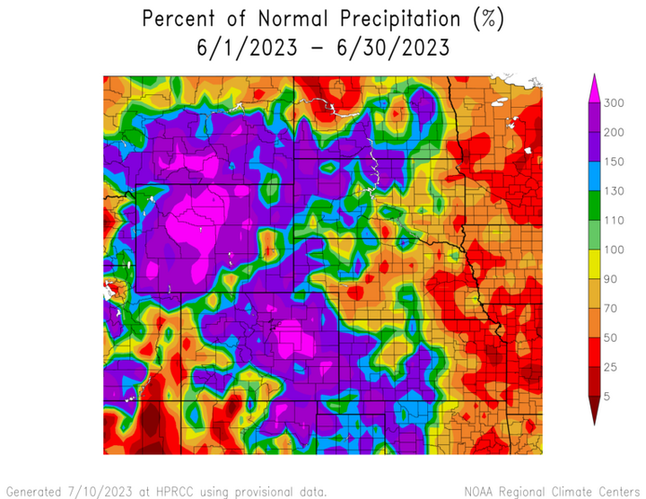
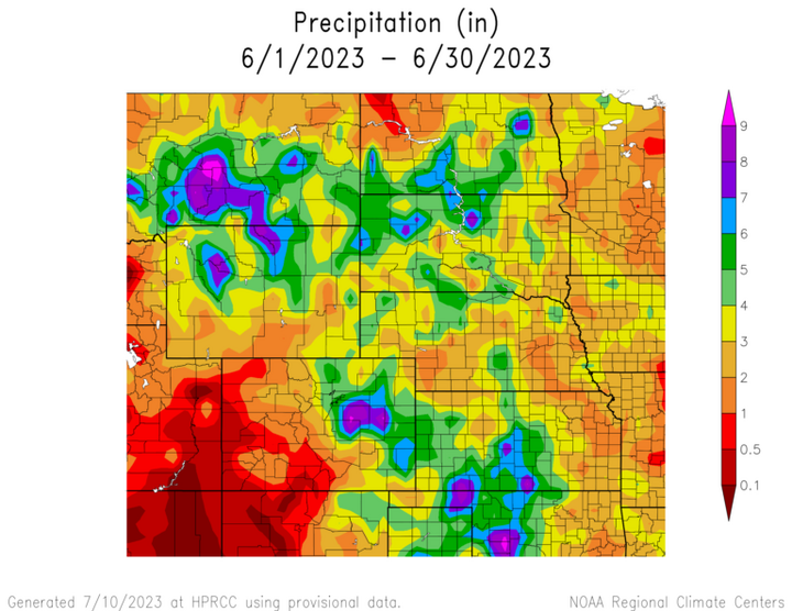
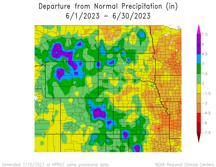
The trend of above-normal precipitation in the west and below-normal to the east continued into June. The Front Range and Rocky Mountains observed record to near-record amounts, while eastern Kansas was below 25 percent of their normal.
Drought conditions were erased from the state of Colorado after this month’s record precipitation, with only minimal dryness left. Denver surpassed their previous record by over an inch (2.54 cm), with 6.10 inches (15.49 cm) of precipitation. Nearby Akron set their new record after 7.48 inches (19 cm) fell there. Colorado Springs received 9.62 inches (24.44 cm) to break the previous record, which is nearly 60 percent of its annual precipitation.
Another benefactor from the recent precipitation was Wyoming. Numerous locations recorded one of their wettest months on record, while others like Laramie and Sheridan nearly broke theirs. Similar to Colorado, drought conditions greatly improved across the state.
The severe weather this month was both ends of the extreme. The Dakotas observed record-low issuances of tornado warnings for June (period of record 2003-2023), with only three total issued for both states. On the opposite end of the spectrum, Colorado and Wyoming had near-record numbers of tornado warnings. Colorado had a particularly nasty month, with 71 tornado warnings issued and a whopping 152 reports of hail.
Snowpack melted in June, with the mainstem storage approaching the average. Releases from Gavins Point dam have been adjusted to near normal. Streamflow is average to above normal across the region except for eastern Kansas and Nebraska.
| 
|
Temperatures
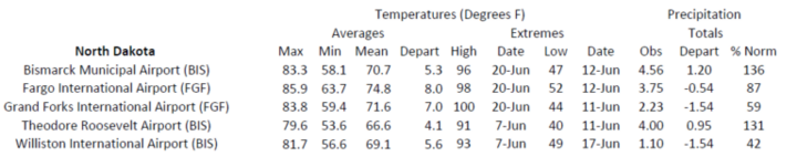
Record to near-record warmth continued in the northern part of the region this month. Parts of North Dakota were 6 degrees F (3.3 degrees C) above normal, while the cooler and wetter western portions were up to 4 degrees F (2.2 degrees C) below normal.
In North Dakota, Fargo and Grand Forks recorded their warmest June of 74.8 degrees F (23.8 degrees C) and 71.6 degrees F (22 degrees C). Both locations recorded their warmest May-June, after having their second warmest May the previous month. This contrasts sharply with early spring, when well below temperatures dominated North Dakota. Elsewhere in the Dakotas, Aberdeen and Sisseton ranked in the Top 5 warmest.
While temperatures have not been excessively hot this year in eastern Nebraska, they have been steadily very warm. At the end of June, Lincoln had recorded 46 days at or above 85 degrees F (29.4 degrees C) for the year. This is the most on record for the first six months of a year, with two more days than 1934 which was the warmest year on record.
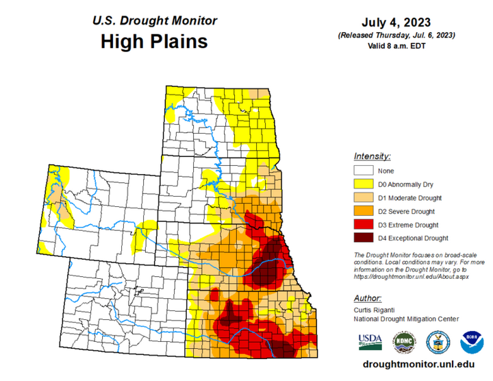
Drought Conditions
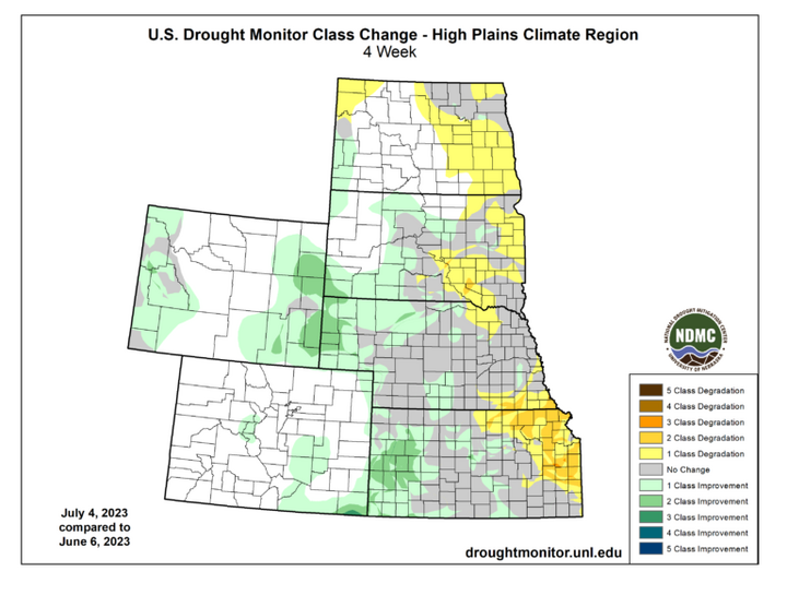
Drought conditions further improved in June, particularly in Kansas. Eastern Nebraska continued to remain dry, with exceptional drought (D4) observed over much of the area. Overall, abnormally dry to exceptional drought (D0-D4) was reduced by nearly seven percent in the High Plains.
The steady stream of precipitation in Kansas brought relief this month. D4 was reduced by nine percent, with only small pockets remaining in the state. Nebraska experienced improvements in the west and degradation in the east. Drought is firmly entrenched across the eastern part of the state, after yet another dry month. Elsewhere in the region, other localized improvements and degradations were observed.
| 
|
The U.S. Drought Monitor is produced as a joint effort of the U.S. Department of Agriculture (USDA), National Drought Mitigation Center, U.S. Department of Commerce, and the National Oceanic and
Atmospheric Administration (NOAA). For current Drought Monitor information, please see: http://droughtmonitor.unl.edu/
Climate Outlooks
According to the Climate Prediction Center, an El Niño Advisory has been issued and conditions are likely to increase over the coming months. For more information, visit https://www.cpc.ncep.noaa.gov/products/analysis_monitoring/lanina/enso_evolution-status-fcsts-web.pdf
The National Weather Service’s long-range flood outlook indicates increased chances of Minor Flooding in central South Dakota and western Nebraska. According to the National Interagency Fire Center (NIFC), fire potential will be limited across the region through October.
The seasonal temperature and precipitation outlook presented below combine the effects of long-term trends, soil moisture, and when applicable, the El Niño Southern Oscillation (ENSO). To learn more about these outlooks, please visit http://www.cpc.ncep.noaa.gov.
Temperature
The three-month temperature outlook shows an increased chance of above-normal temperatures across the majority of the United States. Increased chances of above-normal temperatures are present in Colorado, Kansas, and Wyoming.

Precipitation
The outlook for the next three months indicates below-normal precipitation across the southwestern and northwestern United States, while above-normal precipitation is favored for the central part of the country. Kansas, Nebraska, South Dakota, and Wyoming have increased chances of above normal precipitation.

Drought
The U.S Seasonal Drought Outlook released on June 30th indicates drought conditions will likely improve across the region.

Station Summaries: By the Number

|

|

|
|

|

|