Regional Significant Events for June – August 2025

Highlights for the Basin
Training thunderstorms across central Nebraska on June 25-26 led to record-setting amounts of rainfall. In just those two days, 7.52 inches of rain fell at the Grand Island airport and would set the record for the wettest two-day stretch. Flash flooding would occur, with dozens of motorists stranded and significant damage to the city.
A powerful derecho swept across North Dakota in June, resulting in significant damage throughout the state. Ahead of the derecho, several strong tornadoes touched down. One of which would lead to three fatalities and be the deadliest in the state since 1978. The governor would issue a statewide disaster declaration due to the damage to agriculture and infrastructure.
Regional Climate Overview for June – August 2025
Temperature and Precipitation Anomalies
While temperatures were slightly above normal for the majority of the basin, there were several bouts of heat and well below normal temperatures. Sanders County, Montana, observed its warmest minimum temperatures this summer, while another 14 counties ranked in the top five. This summer was extremely humid, particularly in Kansas, Nebraska, and South Dakota.
Precipitation this summer was, for the most part, above normal for the eastern half of the basin. June and July were exceptionally wet in Nebraska, while in August, the heavy rainfall shifted to Kansas and portions of the Dakotas. A total of nine counties in Kansas, Nebraska, and South Dakota recorded their wettest summer on record, while another 30 ranked in the top five.

Departure from Normal Temperature (°F) for the Winter of 2024-2025

Percent of Normal Precipitation for the Winter of 2024-2025
Changes in Drought Conditions
The map above shows the areas of increasing (yellow shading) and decreasing (green shading) categories of drought. Up to 4 classes of degradation occurred in western Montana after a very dry summer. While to the east of the Rockies, ample precipitation this summer led to three classes of improvements in Nebraska and along the border of Montana and North Dakota.

Regional Impacts for June – August 2025
Agriculture
Despite the improvements in drought conditions this summer, soil moisture was not recharged. The rain was too abundant in parts of Kansas, leading to wheat fields being burned after the crop had spoiled. While the rains were less than optimal for winter wheat, other crops such as corn and soybeans are in great shape, with nearly 60 percent of both crops rated as good to excellent. Pasture conditions are in much better shape than last year.

Wet fields in northeastern South Dakota, credit Kurt Zuehlke
Water Resources
According to the U.S. Army Corps of Engineers, runoff in the Upper Missouri Basin above Sioux City, Iowa is projected to be 74 percent of normal in 2025. Bureau of Reclamation reservoirs are being drawn from, which will lead to reservoir levels beginning the water year below normal.

Flooding in Grand Island, Nebraska, credit Hunter Holliday
Wildfires
Dryness plaguing the western half of the basin led to several large fires. Approximately 125,000 acres were burned in the Red Canyon Fire in central Wyoming after a lightning strike. Nearby, both the Dollar Lake and Sleeper Ranch fires burned just under 20,000 acres each. Across the border in Montana, numerous smaller fires burned this summer.

View of Medicine Bow Forest, credit Gavin Rush
Regional Outlook for October – December 2025
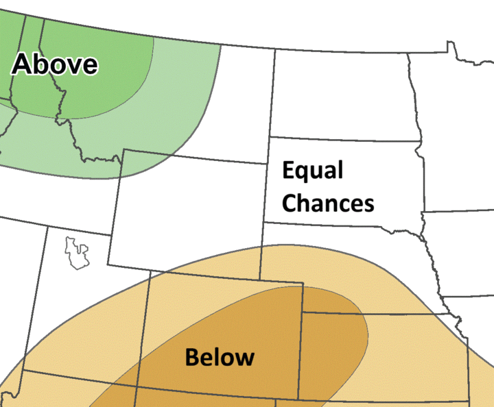
According to NOAA’s Climate Prediction Center, the outlook for the upcoming season indicates increased chances of above-normal temperatures across most of the Basin, except for North Dakota and the majority of Montana. Increased chances of below-normal precipitation are present in Colorado, Kansas, and Nebraska, while chances of above-normal precipitation are possible in western Montana. The rest of the Basin has equal chances of above, below, and near-normal precipitation.
Due to the recent wetness across the eastern portions of the basin, there are concerns about crop dry down combined with increased input costs this fall. La Niña is expected this fall; however, the impacts will likely be more prevalent in the winter.
Temperature

EC: Equal chances of above, near, or below normal, A: Above normal, B: Below normal
Precipitation
EC: Equal chances of above, near, or below normal, A: Above normal, B: Below normal
MO River Basin Partners
High Plains Regional Climate Center
www.hprcc.unl.edu
National Drought Mitigation Center
http://drought.unl.edu/
National Integrated Drought Information System
https://www.drought.gov/
NOAA NCEI
www.ncdc.noaa.gov
NOAA NWS – Central Region
www.weather.gov/crh
NOAA NWS Climate Prediction Center
www.cpc.ncep.noaa.gov
NOAA NWS Missouri Basin River Forecast Center
www.weather.gov/mbrfc
American Association of State Climatologists
https://www.stateclimate.org/
U.S. Army Corps of Engineers
www.nwd-mr.usace.army.mil/rcc/
U.S. Bureau of Reclamation
https://www.usbr.gov/
USDA Natural Resources Conservation Service
www.nrcs.usda.gov
USDA Northern Plains Climate Hub
www.climatehubs.oce.usda.gov
Bureau of Indian Affairs – Great Plains Region
www.bia.gov/regional-offices/great-plains