Regional Significant Events for December 2024 – February 2025
Highlights for the Basin
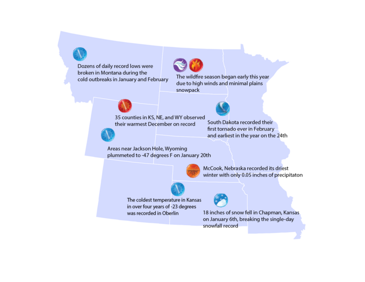
The northern plains experienced several large temperature swings this winter. The coldest temperatures, -45°F, were observed in portions of Montana and western North Dakota. While further south, temperatures dropped below -20°F in Kansas in mid-February. Combined with gusty conditions, wind chills were as low as –68°F in Bowbells, North Dakota. Just a few days later, temperatures soared into the 70s, with some stations reporting 100-plus degree F changes.
Outside of the Rocky Mountains and eastern Kansas, snowfall was well below normal this winter. Parts of the Dakotas and Nebraska were 25 inches below their normal snowfall at the end of February. After a dry fall, conditions were optimal for fires, with dozens igniting in South Dakota and central Nebraska.
Regional Climate Overview for December 2024 – February 2025
Temperature and Precipitation Anomalies
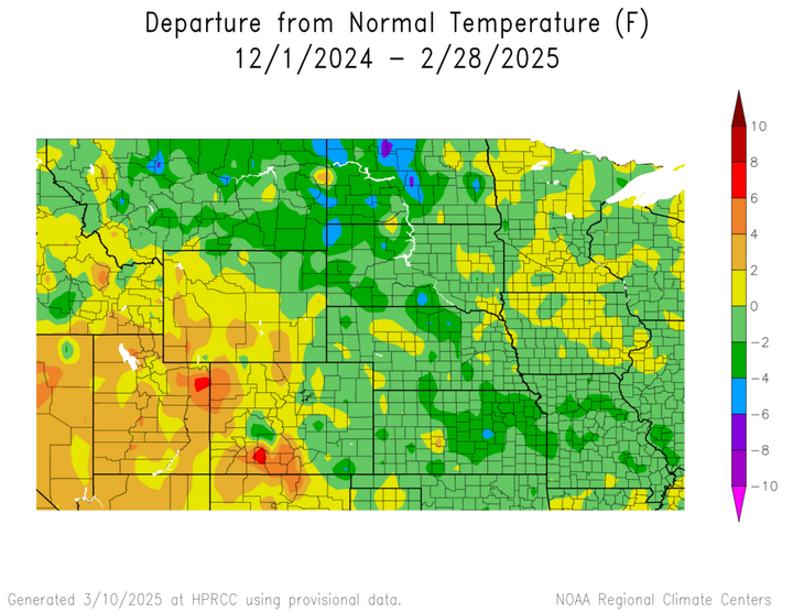
Despite a warm start, temperatures this winter were mostly below normal. December was the 4th warmest on record for the Missouri Basin states, with dozens of counties experiencing their warmest on record. Outbreaks of arctic air in the middle of January and February led to below-normal temperatures in both months.
This winter was dry, with snowfall well below normal across much of the northern and central plains. Precipitation in December was virtually nonexistent in KS and NE, with 18 counties ranking driest. January brought some moisture to eastern KS and the western portions of the basin, but it was still well below normal across the eastern parts of the Dakotas and Nebraska. Precipitation was spotty in February outside of MT and northwestern WY.

Changes in Drought Conditions
Compared to last year, drought conditions are significantly worse. Only 25 percent of the basin was in drought at the end of February last year, while 65 percent is this year. Portions of Nebraska, the Dakotas, and Wyoming experienced up to four classes of degradation, with drought firmly entrenched after the dryness this winter.

Regional Impacts for December 2024 – February 2025
Agriculture
Below normal snowfall has soils and crops in poor shape within the basin. Winter wheat is struggling in Nebraska and South Dakota, with over 35 percent rated as poor to very poor in both states. Frost depths in North Dakota reached 70 inches due to minimal snow cover, while ponds and dugouts are dry from the overall lack of moisture dating back to the fall.

Water Resources
Snowpack in the mountains is in good shape, particularly in the Northern Rockies. However, runoff is projected to be 86 percent of normal, with lower spring and summer releases expected. The temperature swings led to ice jams on the Missouri River, with some minor power shutdowns due to lower flows downstream from the jams.

Transportation
Near-record snows across eastern Kansas and western Missouri in January wreaked havoc on transportation. The Kansas City metro spent over half its annual snow removal budget on the blizzard in January, with three fatalities from car crashes in the state of Kansas. To the north, the snowstorm in February led to two deaths and hundreds of wrecks in Nebraska.

Regional Outlook for April – June 2025
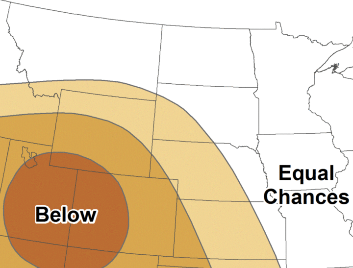
According to NOAA’s Climate Prediction Center, the outlook for the upcoming season indicates increased chances of above-normal temperatures across the southern portions of the Basin. Increased chances of below-normal precipitation are present in Kansas, Nebraska, Wyoming, and parts of Montana and South Dakota. The rest of the Basin has equal chances of above, below, and near-normal precipitation.
La Niña influences will end this spring, and ENSO-neutral conditions will likely be present through the summer. After a dry fall and winter, above normal temperatures and below normal precipitation this spring would be
detrimental to rangeland production and soil moisture.
Temperature

Precipitation
MO River Basin Partners
High Plains Regional Climate Center
www.hprcc.unl.edu
National Drought Mitigation Center
http://drought.unl.edu/
National Integrated Drought Information System
https://www.drought.gov/
NOAA NCEI
www.ncdc.noaa.gov
NOAA NWS – Central Region
www.weather.gov/crh
NOAA NWS Climate Prediction Center
www.cpc.ncep.noaa.gov
NOAA NWS Missouri Basin River Forecast Center
www.weather.gov/mbrfc
American Association of State Climatologists
https://www.stateclimate.org/
U.S. Army Corps of Engineers
www.nwd-mr.usace.army.mil/rcc/
U.S. Bureau of Reclamation
https://www.usbr.gov/
USDA Natural Resources Conservation Service
www.nrcs.usda.gov
USDA Northern Plains Climate Hub
www.climatehubs.oce.usda.gov
Bureau of Indian Affairs – Great Plains Region
www.bia.gov/regional-offices/great-plains