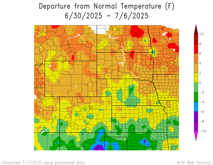
Temperature
Temperatures were above normal for the majority of the region. The highest temperatures were in northern North Dakota and northern South Dakota, reaching 6°F to 8°F above normal. The lowest temperatures were 4°F to 6°F below normal in southeastern Colorado.
Temperatures in northern North Dakota, along the central border of North and South Dakota, and northwestern Wyoming reached 8°F to 10°F above normal. The hottest temperature was 93°F at Grand Junction, Colorado, which is 1°F below normal for the area, and Salina, Kansas, which is the normal temperature for the area at this time. The coolest temperatures were 4°F to 6°F below normal in southwestern Colorado and southcentral Kansas.
Temperatures in southeastern Colorado reached temperatures 4°F to 8°F below normal. The coldest temperature was 52°F at Casper, Wyoming, which is 2°F above normal for the area, and at Sheridan, Wyoming, which is 1°F above normal for the area. The warmest temperatures were 6°F to 8°F in northeastern North Dakota and northeastern South Dakota.
| 
| 
|
Precipitation
Precipitation amounts varied this week, ranging from 2 percent of normal across central and northwestern North Dakota, scattered parts of central South Dakota, along the Colorado-Nebraska-Kansas borders, across southern Colorado, and central and northern Wyoming to 400 percent of normal in southwestern Wyoming and western Kansas. Norcatur, Kansas received 5.56 inches of precipitation; most of it fell on the 5th. Drought continues in the region. D0 (abnormally dry) conditions remained the same as the previous week. In the region, Nebraska experienced the highest decrease in D0 conditions by 5 percent while North Dakota experienced an increase in D0 conditions by 12 percent.

| 
|
Severe Storms
North Dakota received hail 1 inch in diameter. South Dakota and Wyoming received hail 1 to 1.75 inches in diameter. Colorado received hail 1 to 2 inches in diameter and reported one tornado touching down the afternoon of the 6th. Nebraska and Kansas received hail of 1 to 2.75 inches and 1 to 3 inches in diameter, respectively.